May. 29, 2013


TMC Announces New Big Data Traffic Information Service
Toyota City, Japan, May 29, 2013―Toyota Motor Corporation (TMC) announces the development and upcoming launch in Japan of the "Big Data Traffic Information Service", a new kind of traffic-information service utilizing big data including vehicle locations and speeds, road conditions, and other parameters collected and stored via telematics services.
Based on such data, traffic information, statistics and other related information can be provided to local governments and businesses to aid traffic flow improvement, provide map information services, and assist disaster relief measures. Applications by local governments and businesses across Japan to use the service will be accepted starting June 3.
Concurrently, the existing smart G-BOOK telematics service for smartphones will be upgraded to allow private users access to Big Data Traffic Information Service content.
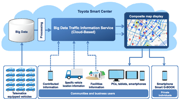
1. Big Data Traffic Information Service
Not only will local governments and businesses be able to utilize Toyota's proprietary T-Probe traffic information1, route history, traffic volume maps, and other map information derived from big data, the platform will also allow users to display system information together with their own content, opening up a wide range of uses, such as for emergency and disaster relief operations and for traffic and logistics systems.
2. New smart G-BOOK service for smartphones
For the first time, T-Probe traffic information will be available for systems other than Toyota navigation systems, and the newly established, cloud-based Toyota Smart Center will provide a voice recognition agent function for processing spoken (Japanese language) queries2.
TMC sees the Big Data Traffic Information Service and the linked smart G-BOOK service as comprehensive lifestyle services that contribute to environment-friendly, safe and disaster-resilient communities.
Big Data Traffic Information Service
Main Features
The cloud-based service allows use of Toyota's proprietary T-Probe traffic information, route history, traffic volume map, deployment locations of ABS or other on-board emergency safety systems, and other map information data via PC, smartphone, or tablet.
Information about facilities owned or operated by local governments and businesses and locations of commercial vehicles can be shown on the map, while information and images can be submitted by users via smartphones.
In disaster situations, information about evacuation sites, shelters, and other facilities can be shown, with the location of rescuers (equipped with smartphones) and emergency and relief vehicles also indicated on the map.
To facilitate damage assessment and relief efforts during times of emergency, rescue personnel can submit damage information and make relief requests via smartphone, with this information being shown along with T-Probe traffic information, route history, and hazard maps provided by local governments.
At other times, the service can be used for traffic and logistics systems. Suitable processing of T-Probe traffic information enables map-based route planning for effective guidance to multiple destinations, along with location tracking and travel history management.
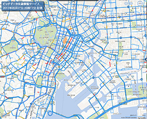
T-Probe traffic information
(Traffic congestion status shown with color coding)
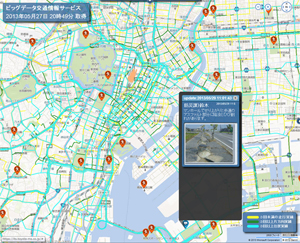
Route history
(Successfully traveled routes and traffic volume shown
with color coding)
Target users
Local governments and businesses across Japan (display and service contents can be flexibly customized according to requests)
| Services | Cost | ||||||||||||||||||||
|
|
||||||||||||||||||||
Contact for applications
- Toyota Media Service (TEL: 052-219-6700)
New smart G-BOOK service for smartphones
Service description
1) Car navigation utilizing T-Probe traffic information
The upgraded service features full support for a range of mobility options, from driving to walking and features T-Probe traffic information (available for the first time on systems other than official Toyota on-board navigation systems) that enables tailored route calculation taking traffic congestion in account.
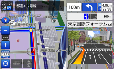
Usability has been enhanced with a complete range of functions, including enlarged views of intersections, 3D display of landmarks and voice announcement of place names. Linking with smartphone-compatible navigation displays (dealer-installed option) is also supported (iPhone 4, 4S, others).
2) Agent: Toyota Smart Center-based voice-recognition service (Japanese language)
Queries for desired destinations can be open and expressed naturally, for example: "Find the nearest convenience store", or "An open sushi bar on Harumi Street". If the agent is unable to answer adequately, the query is handed over to a human operator for follow-up.
3) Route history
User-accumulated traveled route history can be displayed at any time. During disaster or emergency situations, guidance can be provided to evacuation sites. By linking to traffic information provided from local governments, evacuation and disaster information can also be provided to users.
4) Traffic information SNS
If a user encounters a road hazard, or encounters an accident or traffic jam, the information can be reported with a simple touch with stamps. Such information can also be viewed by other users of the Big Data Traffic Information Service.
Target users
- smart G-BOOK: User registration available to all smart G-BOOK users
- G-BOOK: User registration available to owners of G-BOOK compatible models
Supported devices and schedule
- Android smartphones: From June 3, 2013 (planned)
- iOS smartphones: From mid-June 2013 (planned)
Service content and pricing
- Free of charge: User registration enables access to disaster relief services, route check.
- 2,500 yen per year (incl. tax): Use of operator service and traffic Information SNS
A special pricing campaign will be conducted at launch: yearly fee discounted to 1,000 yen (includes tax) for first 20,000 users (10,000 each for Android and iOS).
1,000 yen per year (incl. tax): Use of VICS traffic information
| Cost | Service | Content | |||||||
| Free | Disaster relief service |
Route history | Record of users' traveled routes | ||||||
| Related facility search |
|
||||||||
| HELPNET | Automatic sending of location information, linking to police and firefighting services | ||||||||
| Route check | T-Probe traffic information | Display of Toyota probe traffic information data | |||||||
| Spot search | Search for location of facilities, shops, etc. | ||||||||
| Route display (car/on foot) | Display of route from current location to desired location | ||||||||
| Fee-based Annual cost: 2,500 yen (incl. tax) |
Navigation | Car/pedestrian navigation |
|
||||||
| T-Probe traffic information | Toyota probe traffic information reflected in route search and guidance | ||||||||
| Voice guidance | Linked to GAZOO virtual bus guide (from autumn 2013 onwards) | ||||||||
| Link to on-board display | Linking with a smartphone-compatible navigation displays | ||||||||
| Agent: Toyota Smart Center-based voice recognition service | Destination search using colloquial or ambiguous expression possible | ||||||||
| Operator service | Requests can be made in direct conversation with human operator | ||||||||
| Traffic information SNS |
|
||||||||

Navigation screen example
(3D landmarks)
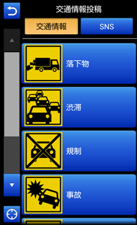
SNS traffic condition report icons
1Real-time traffic information generated from telematics-provided data about vehicle location, travel speed, and other parameters
2Route guidance function to be added from August 2013